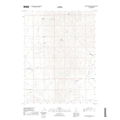
2020 Map of Onaqui Mountains South
USGS Topo · Published 2020About this map
The Onaqui Mountains form a rugged backbone through this section of Tooele County, where steep drainage systems like Skull Faust Canyon and East Faust Canyon define the landscape. Water sources remain critical features in this arid environment, marked by the presence of Hellhole Spring and Rock Canyon Spring. To the west, the distinctive Davis Knolls rise near the floor of Rush Valley, while Little Mtn anchors the southern terrain. This 2020 survey records a network of utilitarian infrastructure, including the Pony Express Rd, which traces a historic corridor across the southern expanse, alongside modern routes like Aqueduct Rd, Pipeline Rd, and Waterline Rd, reflecting the ongoing human management of these high-desert canyons.
Find a feature on this map
29 named features on this map. Tap any name to fly to it.
Don’t see what you’re looking for? This feature index may not catch every label — zoom into the map to look around manually.
Map Details
Editions of this 2020 Onaqui Mountains South Map
This is the sole edition of this map. No revisions or reprints were ever made.
Other maps of this area

1885 · Tooele Valley
USGS Topo · 1:250,000

1918 · Stockton
USGS Topo · 1:62,500

1953 · Tooele
USGS Topo · 1:250,000

1955 · Indian Peaks
USGS Topo · 1:24,000

1955 · Davis Knolls
USGS Topo · 1:24,000

1955 · Deseret Peak
USGS Topo · 1:62,500

1955 · Stockton
USGS Topo · 1:62,500

1955 · Tooele
USGS Topo · 1:250,000
1971 · Faust
USGS Topo · 1:24,000

1971 · Onaqui Mts South
USGS Topo · 1:24,000