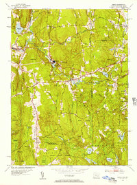
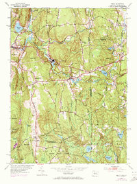
1953 Map of Oneco
USGS Topo · Published 1957About this map
Moosup River drainage patterns define this mid-century landscape along the Connecticut and Rhode Island border, where industrial hamlets like Sterling and Oneco developed around water power and the New York New Haven and Hartford rail line. The terrain transitions from the steeper ridges of Ekonk Hill and Hopkins Hill in the west toward the pond-dotted lowlands of West Greenwich to the east.
Find a feature on this map
65 named features on this map. Tap any name to fly to it.
Don’t see what you’re looking for? This feature index may not catch every label — zoom into the map to look around manually.
Map Details
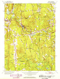
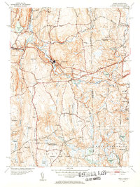
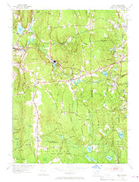
Editions of this 1953 Oneco Map
6 editions found
Historical Maps of Coventry Through Time
77 maps found

1889 Putnam
Windham County, CT

1892 Woodstock
Windham County, CT

1893 Putnam
Windham County, CT

1919 Putnam
Windham County, CT

1921 Woodstock
Windham County, CT

1943 Plainfield
Windham County, CT

1944 Hampton
Windham County, CT

1944 Oneco
Windham County, CT

1945 Eastford
Windham County, CT

1945 East Killingly
Windham County, CT

1945 Putnam
Windham County, CT

1945 Westford
Windham County, CT

1946 Scotland
Windham County, CT

1950 East Killingly
Windham County, CT

1952 Westford
Windham County, CT

1953 Eastford
Windham County, CT

1953 Hampton
Windham County, CT

1953 Oneco
Windham County, CT

1953 Plainfield
Windham County, CT

1953 Scotland
Windham County, CT

1955 East Killingly
Windham County, CT

1955 Putnam
Windham County, CT

1955 Thompson
Windham County, CT

1983 Eastford
Windham County, CT

1983 Plainfield
Windham County, CT

1983 Scotland
Windham County, CT

1983 Westford
Windham County, CT

1984 Hampton
Windham County, CT

2012 Eastford
Windham County, CT

2012 East Killingly
Windham County, CT

2012 Hampton
Windham County, CT

2012 Oneco
Windham County, CT

2012 Plainfield
Windham County, CT

2012 Putnam
Windham County, CT

2012 Scotland
Windham County, CT

2012 Thompson
Windham County, CT

2012 Westford
Windham County, CT

2015 Eastford
Windham County, CT

2015 East Killingly
Windham County, CT

2015 Hampton
Windham County, CT

2015 Oneco
Windham County, CT

2015 Plainfield
Windham County, CT

2015 Putnam
Windham County, CT

2015 Scotland
Windham County, CT

2015 Thompson
Windham County, CT

2015 Westford
Windham County, CT

2018 Eastford
Windham County, CT

2018 East Killingly
Windham County, CT

2018 Hampton
Windham County, CT

2018 Oneco
Windham County, CT

2018 Plainfield
Windham County, CT

2018 Putnam
Windham County, CT

2018 Scotland
Windham County, CT

2018 Thompson
Windham County, CT

2018 Westford
Windham County, CT

2021 Eastford
Windham County, CT

2021 East Killingly
Windham County, CT

2021 Hampton
Windham County, CT

2021 Oneco
Windham County, CT

2021 Plainfield
Windham County, CT

2021 Putnam
Windham County, CT

2021 Scotland
Windham County, CT

2021 Thompson
Windham County, CT

2021 Westford
Windham County, CT

2023 East Killingly
Windham County, CT

2023 Oneco
Windham County, CT

2023 Plainfield
Windham County, CT

2023 Westford
Windham County, CT

2024 Eastford
Windham County, CT

2024 East Killingly
Windham County, CT

2024 Hampton
Windham County, CT

2024 Oneco
Windham County, CT

2024 Plainfield
Windham County, CT

2024 Putnam
Windham County, CT

2024 Scotland
Windham County, CT

2024 Thompson
Windham County, CT

2024 Westford
Windham County, CT