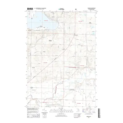
2014 Map of Onekama
USGS Topo · Published 2014About this map
Portage Lake dominates the northern landscape of this region, serving as the focal point for the village of Onekama. The 2014 survey reveals a transition from the established shoreline communities like Red Park and Wic-a-te-wah to the dense woodland of the Manistee National Forest in the south. The area is defined by its water-rich geography, featuring the winding Manistee River and numerous bayous such as Browns Bayou and Jenkins Bayou. Historically significant landmarks include Onekama Junction and several local burial grounds like Saint Joseph Cem and Norwalk Lutheran Cem. The presence of the Manistee County-Blacker Airport in the southwest corner marks the modern infrastructure serving this corner of the Lower Peninsula, while smaller settlements like Douglas and Norwalk maintain the rural character of the interior.
Find a feature on this map
84 named features on this map. Tap any name to fly to it.
Don’t see what you’re looking for? This feature index may not catch every label — zoom into the map to look around manually.
Map Details
Editions of this 2014 Onekama Map
This is the sole edition of this map. No revisions or reprints were ever made.
Other maps of this area

1954 · Manitowoc
USGS Topo · 1:250,000

1956 · Onekama
USGS Topo · 1:62,500

1956 · Bar Lake
USGS Topo · 1:62,500

1957 · Freesoil
USGS Topo · 1:62,500

1958 · Manitowoc
USGS Topo · 1:250,000

1958 · Manistee
USGS Topo · 1:62,500

1976 · Onekama SE
USGS Topo · 1:24,000

1976 · Onekama NW
USGS Topo · 1:24,000

1976 · Onekama SW
USGS Topo · 1:24,000
1976 · Bar Lake SE
USGS Topo · 1:24,000