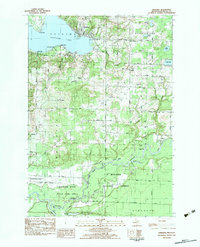
1982 Map of Onekama
USGS Topo · Published 1983About this map
Portage Lake dominates the northwest corner of this Michigan landscape, serving as the focal point for the settlement of Onekama. The 1980s terrain illustrates a transition from the lakeside resort and residential areas of Red Park and Wic-a-te-wah to the dense woodland of the Manistee National Forest. To the south, the Manistee River meanders through the Manistee State Game Area, creating a complex network of wetlands and bayous including Browns Bayou and Borski Bayou. The local infrastructure is defined by the Chesapeake and Ohio rail line and a grid of rural roads like Coates Highway. Genealogists will find significant value in the documentation of several local burial grounds, such as St Joseph Cem Onekama Cem and the Miller Cem, alongside rural landmarks like the Norwalk Ch and various small settlements including Norwalk and Browntown.
Find a feature on this map
66 named features on this map. Tap any name to fly to it.
Don’t see what you’re looking for? This feature index may not catch every label — zoom into the map to look around manually.
Map Details
Editions of this 1982 Onekama Map
This is the sole edition of this map. No revisions or reprints were ever made.
Other maps of this area

1954 · Manitowoc
USGS Topo · 1:250,000

1956 · Onekama
USGS Topo · 1:62,500

1956 · Bar Lake
USGS Topo · 1:62,500

1957 · Freesoil
USGS Topo · 1:62,500

1958 · Manitowoc
USGS Topo · 1:250,000

1958 · Manistee
USGS Topo · 1:62,500

1976 · Onekama SE
USGS Topo · 1:24,000

1976 · Onekama NW
USGS Topo · 1:24,000

1976 · Onekama SW
USGS Topo · 1:24,000
1976 · Bar Lake SE
USGS Topo · 1:24,000