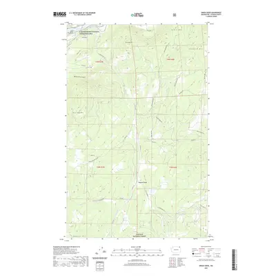
2020 Map of Onion Creek
USGS Topo · Published 2020About this map
The Onion Creek settlement is situated in a high-elevation interior landscape of Stevens County, dominated by the peaks of the Colville National Forest. The northern reach of the map is defined by the Columbia River, here forming part of Franklin D Roosevelt Lake within the Lake Roosevelt National Recreation Area. The terrain is characterized by steep ridges and named summits like Black Hawk Mtn and Alice Mae Mtn, while the drainage of Onion Cr and the W Fork Onion Cr provides the primary orientation for local infrastructure. Evidence of the region's industrial and residential history is seen in the network of forest and access roads, including Van Stone Mine Rd and Widow Hawks Branch Rd, which trace the difficult topography of White Horse Canyon and the surrounding highlands.
Find a feature on this map
36 named features on this map. Tap any name to fly to it.
Don’t see what you’re looking for? This feature index may not catch every label — zoom into the map to look around manually.
Map Details
Editions of this 2020 Onion Creek Map
This is the sole edition of this map. No revisions or reprints were ever made.
Other maps of this area

1929 · Colville
USGS Topo · 1:125,000

1933 · Colville
USGS Topo · 1:125,000

1952 · Gillette Mtn
USGS Topo · 1:24,000

1952 · Spirit
USGS Topo · 1:24,000

1952 · Echo Valley
USGS Topo · 1:24,000

1952 · Boundary
USGS Topo · 1:24,000

1952 · Aladdin
USGS Topo · 1:24,000

1958 · Sandpoint
USGS Topo · 1:250,000

1963 · Sandpoint
USGS Topo · 1:250,000
1966 · Aladdin
USGS Topo · 1:24,000