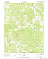
1969 Map of Onondaga Cave
USGS Topo · Published 1971About this map
The Meramec River and its deep-cut tributaries define this Crawford County landscape, where the confluence of Huzzah Creek and Courtois Creek creates a complex network of ridges and hollows. The area is notable for its subterranean features, anchored by the subterranean complexity of Onondaga Cave and Cathedral Cave. In the south, the Huzzah State Wildlife Management Area and portions of the Clark National Forest preserve the dense woodlands surrounding the river bottoms. Small agrarian settlements and landmarks are scattered throughout the hills, from the community at Vilander to the rural Crossroads Ch and Hardy Camp. Local family history is preserved in several upland sites, including the Harrison Cem and the Pleasant Ridge Ch Cem, while industrial traces like the Claypit and a prominent Pipeline cutting through the forest suggest the varied land use of the late 1960s.
Find a feature on this map
36 named features on this map. Tap any name to fly to it.
Don’t see what you’re looking for? This feature index may not catch every label — zoom into the map to look around manually.
Map Details
Editions of this 1969 Onondaga Cave Map
3 editions found
Other maps of this area

1903 · Sullivan
USGS Topo · 1:125,000

1932 · Steelville
USGS Topo · 1:48,000

1933 · Steelville
USGS Topo · 1:62,500

1934 · Meramec State Park
USGS Topo · 1:24,000

1937 · Steelville
USGS Topo · 1:62,500

1937 · Meramec State Park
USGS Topo · 1:24,000

1943 · Berryman
USGS Topo · 1:62,500

1945 · Berryman
USGS Topo · 1:62,500

1947 · Sullivan
USGS Topo · 1:62,500

1948 · Leasburg
USGS Topo · 1:24,000