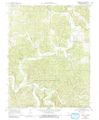
1969 Map of Onondaga Cave
USGS Topo · Published 1991About this map
Onondaga Cave and Cathedral Cave define the karst topography of this corner of Crawford County, where the Meramec River winds through the hills of Liberty and Boone townships. The landscape is marked by a complex network of subterranean features, including Dry Cave, Bat Cave, Bear Cave, and Fault Cave, interspersed with surface water like Blue Springs Creek and Brandel Lake. Small settlements and social centers of the era are scattered across the terrain, from Vilander in the northeast to the riverfront activity at Scotia. The local economy and land use are reflected in the industrial Claypit near Pleasant Ridge Church and the protected lands of the Huzzah State Wildlife Management Area and Clark National Forest. Numerous family and community landmarks, such as Harrison Cemetery and Hardy Camp, provide essential data points for local history and genealogical research.
Find a feature on this map
34 named features on this map. Tap any name to fly to it.
Don’t see what you’re looking for? This feature index may not catch every label — zoom into the map to look around manually.
Map Details
Editions of this 1969 Onondaga Cave Map
3 editions found
Other maps of this area

1903 · Sullivan
USGS Topo · 1:125,000

1932 · Steelville
USGS Topo · 1:48,000

1933 · Steelville
USGS Topo · 1:62,500

1934 · Meramec State Park
USGS Topo · 1:24,000

1937 · Steelville
USGS Topo · 1:62,500

1937 · Meramec State Park
USGS Topo · 1:24,000

1943 · Berryman
USGS Topo · 1:62,500

1945 · Berryman
USGS Topo · 1:62,500

1947 · Sullivan
USGS Topo · 1:62,500

1948 · Leasburg
USGS Topo · 1:24,000