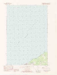
1982 Map of Ontonagon North
USGS Topo · Published 1983About this map
Lake Superior dominates the northern reaches of this coastal map, where the shoreline meets the village of Ontonagon. Surveyed in the early 1980s, the map documents the northern edge of the township, illustrating the community's interface with the water through landmarks such as the Pumping Sta and a navigational Light. The southern portion of the sheet reveals a landscape shaped by local recreation and infrastructure, featuring a Golf Course and a Park and Campground situated near the mouth of the river system.
Find a feature on this map
11 named features on this map. Tap any name to fly to it.
Don’t see what you’re looking for? This feature index may not catch every label — zoom into the map to look around manually.
Map Details
Editions of this 1982 Ontonagon North Map
This is the sole edition of this map. No revisions or reprints were ever made.
Other maps of this area

1950 · Greenland
USGS Topo · 1:62,500

1951 · Greenland
USGS Topo · 1:62,500

1955 · Ontonagon
USGS Topo · 1:62,500

1958 · Hancock
USGS Topo · 1:250,000

1958 · Iron River
USGS Topo · 1:250,000

1960 · Iron River
USGS Topo · 1:250,000

1960 · Hancock
USGS Topo · 1:250,000

1961 · Iron River
USGS Topo · 1:250,000

1961 · Hancock
USGS Topo · 1:250,000

1966 · Hancock
USGS Topo · 1:250,000