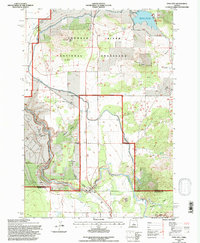
1992 Map of Opal City
USGS Topo · Published 1997About this map
The dramatic geography of central Oregon is defined here by the Crooked River Gorge, where the waterway carves a deep path through the high desert landscape. Located along the border of Jefferson and Deschutes counties, this 1992 survey illustrates a region where managed agricultural waters and natural recreation areas coexist. The Main Canal and North Unit Main Canal weave through the sagebrush and juniper, supporting local ranching while the Crooked River National Grassland preserves the open character of the territory.
Find a feature on this map
28 named features on this map. Tap any name to fly to it.
Don’t see what you’re looking for? This feature index may not catch every label — zoom into the map to look around manually.
Map Details
Editions of this 1992 Opal City Map
This is the sole edition of this map. No revisions or reprints were ever made.
Other maps of this area

1926 · Bend
USGS Topo · 1:125,000

1928 · Madras
USGS Topo · 1:125,000

1929 · Bend
USGS Topo · 1:125,000

1931 · Madras
USGS Topo · 1:125,000

1955 · Bend
USGS Topo · 1:250,000

1957 · Bend
USGS Topo · 1:250,000

1958 · Bend
USGS Topo · 1:250,000

1961 · Redmond
USGS Topo · 1:24,000

1962 · Opal City
USGS Topo · 1:24,000

1962 · Oneil
USGS Topo · 1:24,000