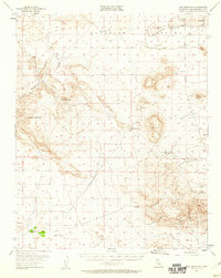
1955 Map of Opal Mountain
USGS Topo · Published 1960About this map
Superior Valley dominates this 1955 survey of the Mojave landscape, where water security dictated the survival of early desert ventures. The map identifies a network of essential water sources including Slocum Well, Murphys Well, and Crutts Well, which supported both livestock and transient mining operations. Geologic and archaeological interest is concentrated in the southern hills, specifically around the Rainbow Basin and Fossil Canyon, while Inscription Canyon hints at the region's deeper cultural history. Settled life is represented by isolated outposts such as Coolgardie Camp and the agricultural efforts at Blacks Ranch and Rainbow Ranch near the edge of Harper Lake. The presence of scattered shafts and prospects near Opal Mountain reflects the mid-century mineral exploration that characterized this section of San Bernardino County.
Find a feature on this map
27 named features on this map. Tap any name to fly to it.
Don’t see what you’re looking for? This feature index may not catch every label — zoom into the map to look around manually.
Map Details
Editions of this 1955 Opal Mountain Map
3 editions found

Other maps of this area

1915 · Searles Lake
USGS Topo · 1:250,000

1932 · Barstow
USGS Topo · 1:125,000

1933 · Avawatz Mountains
USGS Topo · 1:250,000

1934 · Barstow
USGS Topo · 1:125,000

1947 · Trona
USGS Topo · 1:250,000

1948 · Trona
USGS Topo · 1:250,000

1948 · Lane Mountain
USGS Topo · 1:62,500

1948 · Goldstone Lake
USGS Topo · 1:62,500

1951 · Goldstone Lake
USGS Topo · 1:62,500

1951 · Lane Mountain
USGS Topo · 1:62,500