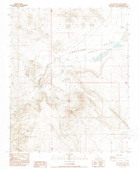
1988 Map of Opal Mountain
USGS Topo · Published 1988About this map
Opal Mountain and the surrounding Mojave Desert high country are defined by a network of four-wheel-drive tracks and scattered mineral exploration sites. This late twentieth-century survey reveals a landscape focused on resource potential, with numerous Prospects and a Quarry located near the rugged slopes of Black Mountain. To the north, the terrain drops into the Superior Valley, where the ephemeral Superior Lake and the arid Slocum Well illustrate the challenging water conditions of the San Bernardino County interior.
Find a feature on this map
15 named features on this map. Tap any name to fly to it.
Don’t see what you’re looking for? This feature index may not catch every label — zoom into the map to look around manually.
Map Details
Editions of this 1988 Opal Mountain Map
2 editions found
Other maps of this area

1915 · Searles Lake
USGS Topo · 1:250,000

1947 · Trona
USGS Topo · 1:250,000

1948 · Trona
USGS Topo · 1:250,000

1953 · Trona
USGS Topo · 1:250,000

1954 · Pilot Knob
USGS Topo · 1:62,500

1954 · Cuddeback Lake
USGS Topo · 1:62,500

1955 · Opal Mountain
USGS Topo · 1:62,500

1956 · Fremont Peak
USGS Topo · 1:62,500

1957 · Trona
USGS Topo · 1:250,000

1960 · Trona
USGS Topo · 1:250,000