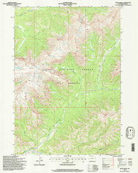
1996 Map of Open Creek
USGS Topo · Published 1998About this map
Teton Wilderness and the surrounding Teton National Forest dominate this high-altitude landscape in Park County, defined by a complex drainage system and prominent geological formations. The topography is marked by the broad Trident Plateau and the striking Petrified Ridge, which overlooks the southeastern quadrant. This area serves as a critical watershed, with Mountain Creek flowing through the north and Open Creek cutting through the central portion, fed by tributaries like Siggins Fork and Silvertip Creek. Human passage through this primitive terrain is traced via the Thorofare Trail, which follows the southern watercourses toward Ishawooa Pass. The absence of roads or permanent settlements highlights the region's character as a protected natural corridor, where the only infrastructure consists of established wilderness paths and creek crossings like those at Ishawooa Creek and Falls Creek.
Find a feature on this map
19 named features on this map. Tap any name to fly to it.
Don’t see what you’re looking for? This feature index may not catch every label — zoom into the map to look around manually.
Map Details
Editions of this 1996 Open Creek Map
This is the sole edition of this map. No revisions or reprints were ever made.
Other maps of this area

1885 · Lake
USGS Topo · 1:125,000

1893 · Ishawooa
USGS Topo · 1:125,000

1895 · Ishawooa
USGS Topo · 1:125,000

1895 · Lake
USGS Topo · 1:125,000

1896 · Lake
USGS Topo · 1:125,000

1899 · Ishawooa
USGS Topo · 1:125,000

1901 · Lake
USGS Topo · 1:125,000

1906 · Lake
USGS Topo · 1:125,000

1911 · Lake
USGS Topo · 1:125,000

1955 · Ashton
USGS Topo · 1:250,000