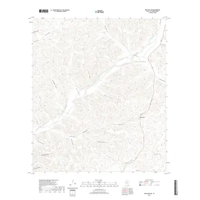
2019 Map of Open Hollow
USGS Topo · Published 2019About this map
Loma Alta sits as the primary settlement node along US Hwy 277 in this arid landscape, where the ephemeral waters of the Dry Devils River and its numerous tributaries have carved a complex network of canyons and draws. The geography is defined by deep incisions like Rough Canyon and Prickly Pear Canyon, which dictate the paths of ranch roads and historic tracks such as Dolan Creek Rd.
Find a feature on this map
29 named features on this map. Tap any name to fly to it.
Don’t see what you’re looking for? This feature index may not catch every label — zoom into the map to look around manually.
Map Details
Editions of this 2019 Open Hollow Map
This is the sole edition of this map. No revisions or reprints were ever made.
Other maps of this area

1943 · Carta Valley
USGS Topo · 1:62,500

1944 · Dry Devil
USGS Topo · 1:62,500

1954 · Sonora
USGS Topo · 1:250,000

1958 · Sonora
USGS Topo · 1:250,000

1958 · Del Rio
USGS Topo · 1:250,000

1964 · Del Rio
USGS Topo · 1:250,000

1973 · Robinson Draw
USGS Topo · 1:24,000

1973 · Four Mills
USGS Topo · 1:24,000
1973 · White Draw
USGS Topo · 1:24,000
1978 · Holcomb Draw
USGS Topo · 1:24,000