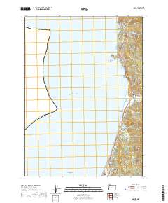
2020 Map of Ophir
USGS Topo · Published 2020About this map
Arizona Beach and the rugged shoreline of Curry County define this coastal landscape, where the land meets the Pacific Ocean along a series of distinctive landforms. The settlement of Ophir serves as a central point for the local road network, including Euchre Creek Rd and Squaw Valley Rd, which follow the drainage of Euchre Creek. To the south, the community of Nesika Beach sits near Vondergreen Hill, marking a shift in the coastal topography as the hills recede from the surf.
Find a feature on this map
34 named features on this map. Tap any name to fly to it.
Don’t see what you’re looking for? This feature index may not catch every label — zoom into the map to look around manually.
Map Details
Editions of this 2020 Ophir Map
This is the sole edition of this map. No revisions or reprints were ever made.
Other maps of this area

1899 · Port Orford
USGS Topo · 1:125,000

1903 · Port Orford
USGS Topo · 1:125,000

1954 · Coos Bay
USGS Topo · 1:250,000

1954 · Port Orford
USGS Topo · 1:62,500

1954 · Gold Beach
USGS Topo · 1:62,500

1958 · Coos Bay
USGS Topo · 1:250,000

1962 · Coos Bay
USGS Topo · 1:250,000
1986 · Father Mountain
USGS Topo · 1:24,000
1986 · Ophir
USGS Topo · 1:24,000
1986 · Port Orford
USGS Topo · 1:24,000