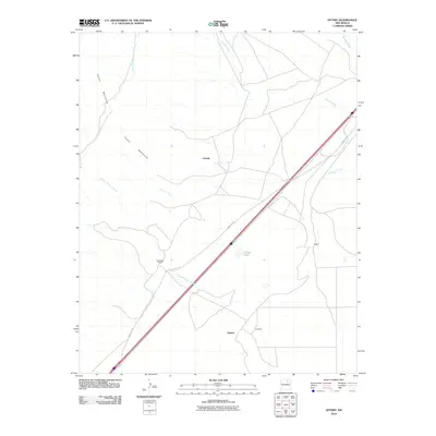
2010 Map of Optimo
USGS Topo · Published 2010About this map
The Santa Fe Trl cuts a bold diagonal across this high plains landscape, following an ancient corridor of travel through Mora County. This modern survey illustrates the enduring geography of the trail as it bypasses the southeastern foothills of the Turkey Mountains. Small ranching hubs and historic stops punctuate the arid terrain, including the community of Optimo and the nearby Howland site. The drainage patterns of the region are defined by seasonal waterways such as Arroyo Tierra Blanca and Arroyo Chorro, which converge as they flow toward the northeast. Settlement remains sparse, represented by isolated locations like Christmas Ranch, Ciruela, and Wiggins, alongside the small reservoir at Calleys Lake. This map provides a clear view of how modern transportation and property lines have overlaid the historic ranching tradition of northeastern New Mexico.
Find a feature on this map
12 named features on this map. Tap any name to fly to it.
Don’t see what you’re looking for? This feature index may not catch every label — zoom into the map to look around manually.
Map Details
Editions of this 2010 Optimo Map
This is the sole edition of this map. No revisions or reprints were ever made.
Other maps of this area

1892 · Watrous
USGS Topo · 1:125,000

1894 · Watrous
USGS Topo · 1:125,000

1954 · Santa Fe
USGS Topo · 1:250,000

1954 · Raton
USGS Topo · 1:250,000

1958 · Raton
USGS Topo · 1:250,000

1958 · Santa Fe
USGS Topo · 1:250,000

1964 · Wagon Mound
USGS Topo · 1:24,000

1964 · Frutosa Lake
USGS Topo · 1:24,000

1964 · Mogote Hills
USGS Topo · 1:24,000
1966 · Watrous
USGS Topo · 1:24,000