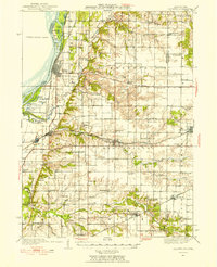
1934 Map of Oquawka
USGS Topo · Published 1954About this map
The Mississippi River defines the western edge of this landscape, where intricate waterways like Benton Slough and Whitehead Slough wrap around Benton Island. Moving inland from the river bluffs, the terrain transitions into a dense network of upland farms and small settlements connected by the Chicago Burlington and Quincy and Atchison Topeka and Santa Fe railroads. This 1930s era reveals a highly localized social geography, evidenced by the sheer density of country schoolhouses such as Little Brick Sch, Dutch Row Sch, and Junkins Sch. The map records a moment when rural life centered on these one-room institutions and village hubs like Oquawka and Stronghurst. Family history researchers can locate numerous burial grounds, including Coghill Cem and Kemp Cem, and distinctive landmarks like the Davenport Bridge and the Airway Beacon near Gladstone.
Find a feature on this map
90 named features on this map. Tap any name to fly to it.
Don’t see what you’re looking for? This feature index may not catch every label — zoom into the map to look around manually.
Map Details
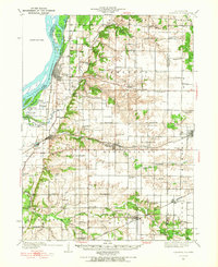
Editions of this 1934 Oquawka Map
3 editions found
Other maps of this area

1916 · Good Hope
USGS Topo · 1:62,500

1918 · La Harpe
USGS Topo · 1:62,500

1918 · Good Hope
USGS Topo · 1:62,500

1921 · Monmouth
USGS Topo · 1:62,500

1923 · Monmouth
USGS Topo · 1:62,500

1923 · Alexis
USGS Topo · 1:62,500

1925 · Alexis
USGS Topo · 1:62,500

1932 · Lomax
USGS Topo · 1:62,500

1934 · Oquawka
USGS Topo · 1:48,000

1934 · Burlington
USGS Topo · 1:48,000