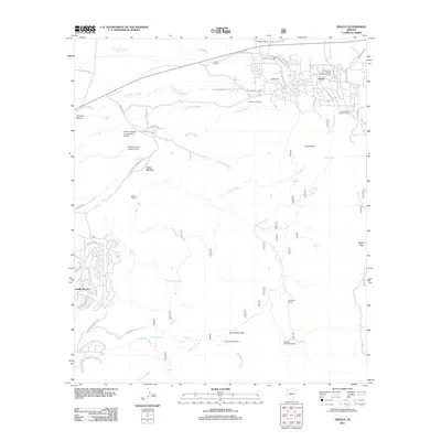
2011 Map of Oracle
USGS Topo · Published 2011About this map
The high-desert community of Oracle serves as the focal point for this survey of the northern foothills of the Santa Catalina Mountains. The landscape is defined by its transition from established ranching properties like Rancho Linda Vista and Rancho Solano to modern developments such as Saddle Brooke. The area's specialized aviation and scientific footprint is marked by the Little Hill Mines Incorporated Airport and the Biosphere Two Landing Field.
Find a feature on this map
67 named features on this map. Tap any name to fly to it.
Don’t see what you’re looking for? This feature index may not catch every label — zoom into the map to look around manually.
Map Details
Editions of this 2011 Oracle Map
This is the sole edition of this map. No revisions or reprints were ever made.
Other maps of this area

1904 · Tucson
USGS Topo · 1:125,000

1905 · Tucson
USGS Topo · 1:125,000

1911 · Winkelman
USGS Topo · 1:125,000

1913 · Winkelman
USGS Topo · 1:125,000

1948 · Mammoth
USGS Topo · 1:62,500

1948 · Mammoth
USGS Topo · 1:24,000

1948 · Campo Bonito
USGS Topo · 1:24,000

1949 · Mammoth
USGS Topo · 1:24,000

1949 · Campo Bonito
USGS Topo · 1:24,000
1951 · Mammoth
USGS Topo · 1:62,500