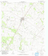
1979 Map of Orange Grove
USGS Topo · Published 1991About this map
Orange Grove serves as the primary hub of activity in this South Texas landscape, where the town’s grid is bisected by the Southern Pacific Railroad. The surrounding terrain is defined by a series of drainages, including the prominent Agua Dulce Creek and Quinta Creek, which carve through a countryside increasingly marked by energy infrastructure. Numerous oil and gas wells, interconnected by an extensive network of pipelines, illustrate the region’s industrial character during the late 1970s. To the southwest, the smaller settlement of Alfred sits near Tecolote Creek, while several family-named landmarks such as Mc Neill Cem, Reynolds Cem, and Adams Cem provide valuable touchpoints for genealogists and local historians. The map also records the presence of various Gravel Pits and Sewage Disposal Ponds, reflecting the utility and extraction needs of the era.
Find a feature on this map
17 named features on this map. Tap any name to fly to it.
Don’t see what you’re looking for? This feature index may not catch every label — zoom into the map to look around manually.
Map Details
Editions of this 1979 Orange Grove Map
This is the sole edition of this map. No revisions or reprints were ever made.
Other maps of this area

1920 · Mikeska
USGS Topo · 1:125,000

1920 · San Diego
USGS Topo · 1:62,500

1925 · Mathis No. 3
USGS Topo · 1:48,000

1927 · Mathis
USGS Topo · 1:62,500

1950 · Corpus Christi
USGS Topo · 1:250,000

1953 · Crystal City
USGS Topo · 1:250,000

1953 · Beeville
USGS Topo · 1:250,000

1954 · Orange Grove
USGS Topo · 1:62,500

1954 · Mathis
USGS Topo · 1:62,500

1955 · Crystal City
USGS Topo · 1:250,000
Featured Places
- Orange Grove, TX
- Orange Grove Villa Colonia, TX
- West Orange Estates Colonia, TX
- North Orange Estates Colonia, TX
- Yucca Acres Colonia, TX