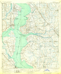
1918 Map of Orange Park
USGS Topo · Published 1932About this map
St Johns River dominates this landscape south of Jacksonville, serving as a massive water highway between the settlements of Orange Park and Green Cove Springs. The map illustrates a transitional era where the river-based economy, evidenced by Neals Dock and Tar Ldg, met the rising influence of the Atlantic Coast Line railroad. Inland from the river bluffs like Beauclerc Bluff, the terrain dissolves into an intricate network of wetlands, including Gum Swamp and Flat Swamp, which dictated the winding paths of the Old Kings Road and St Augustine Road. Local community life is anchored by small rural centers such as Mandarin, Loretto, and Hibernia, each supported by neighborhood institutions like Deep Bottom School and Bethel Church. The detailed surveying also captures numerous fords and creek crossings, including Blacks Ford and Whites Ford, which were critical for overland travel before extensive bridging.
Find a feature on this map
88 named features on this map. Tap any name to fly to it.
Don’t see what you’re looking for? This feature index may not catch every label — zoom into the map to look around manually.
Map Details
Editions of this 1918 Orange Park Map
5 editions found
Other maps of this area

1917 · Orange Park
USGS Topo · 1:62,500

1917 · Cambon
USGS Topo · 1:62,500

1918 · Middleburg
USGS Topo · 1:62,500

1918 · Cambon
USGS Topo · 1:62,500

1918 · Jacksonville
USGS Topo · 1:62,500

1918 · Orange Park
USGS Topo · 1:62,500

1918 · Palm Valley
USGS Topo · 1:62,500

1918 · Mayport
USGS Topo · 1:62,500

1937 · Bakersville
USGS Topo · 1:24,000

1941 · Middleburg
USGS Topo · 1:62,500