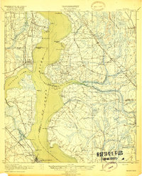
1918 Map of Orange Park
USGS Topo · Published 1918About this map
St Johns River dominates this 1917 military survey, acting as a broad corridor between Duval, Clay, and St Johns counties. This era of Florida history is marked by a landscape transitioning from river-dependent docks and ferries to a rail-and-road network. The Atlantic Coast Line and Florida East Coast Railway trace the banks, connecting established waterfront communities like Orange Park and Hibernia with smaller inland settlements such as Yukon, Loretto, and Bayard.
Find a feature on this map
78 named features on this map. Tap any name to fly to it.
Don’t see what you’re looking for? This feature index may not catch every label — zoom into the map to look around manually.
Map Details
Editions of this 1918 Orange Park Map
5 editions found
Other maps of this area

1917 · Orange Park
USGS Topo · 1:62,500

1917 · Cambon
USGS Topo · 1:62,500

1918 · Middleburg
USGS Topo · 1:62,500

1918 · Cambon
USGS Topo · 1:62,500

1918 · Jacksonville
USGS Topo · 1:62,500

1918 · Orange Park
USGS Topo · 1:62,500

1918 · Palm Valley
USGS Topo · 1:62,500

1918 · Mayport
USGS Topo · 1:62,500

1937 · Bakersville
USGS Topo · 1:24,000

1941 · Middleburg
USGS Topo · 1:62,500