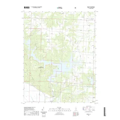
2021 Map of Oraville
USGS Topo · Published 2021About this map
Kinkaid Lake dominates the central landscape of this Jackson County region, where intricate fingers of water reach into the surrounding timberlands of the Shawnee National Forest. The map documents a rural corridor anchored by Oraville in the northeast and the settlement of Grimsby to the south. This area is characterized by a high density of small family burial grounds, including Bartlett Cem, Williamson Cem, and Lone Oak Cem, which are scattered among the ridges and valleys between Rattlesnake Cr and the Big Muddy River. To the southeast, Rendleman Airport sits near the river's edge, while a complex network of hiking paths like the Kinkaid Lake Trl and Waterfall Trl wind through the protected forest bluffs, providing a detailed record of modern recreational access and land use alongside older genealogical landmarks.
Find a feature on this map
78 named features on this map. Tap any name to fly to it.
Don’t see what you’re looking for? This feature index may not catch every label — zoom into the map to look around manually.
Map Details
Editions of this 2021 Oraville Map
This is the sole edition of this map. No revisions or reprints were ever made.
Other maps of this area

1910 · Murphysboro
USGS Topo · 1:62,500

1916 · Campbell Hill
USGS Topo · 1:62,500

1918 · Altenburg
USGS Topo · 1:62,500

1918 · Campbell Hill
USGS Topo · 1:62,500

1924 · Alto Pass
USGS Topo · 1:62,500

1925 · Altenburg
USGS Topo · 1:62,500

1938 · Murphysboro
USGS Topo · 1:62,500

1947 · Alto Pass
USGS Topo · 1:62,500

1947 · Gorham
USGS Topo · 1:24,000

1947 · Altenburg
USGS Topo · 1:62,500