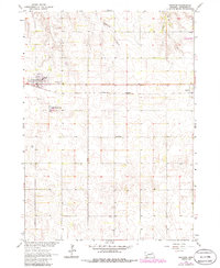
1963 Map of Orchard
USGS Topo · Published 1986About this map
Orchard and Royal anchor this agricultural survey of Antelope County, recorded just as the regional rail landscape was transitioning. The Burlington Northern line runs west-to-east through the center of the sheet, providing a primary transit corridor for these Nebraska prairie towns. The landscape is defined by the drainage of Hathaway Slough and Hay Creek, with the Grove Lake State Wildlife Area appearing in the northeast corner. Cultural landmarks and genealogy-rich sites are scattered across the townships, including Highland Sch and several local burial grounds such as St Peters Cem and the Orchard Cem. These features, along with the municipal infrastructure like the Water Tank and Sewage Disposal Ponds, document the functional layout of rural community life in the mid-20th century.
Find a feature on this map
14 named features on this map. Tap any name to fly to it.
Don’t see what you’re looking for? This feature index may not catch every label — zoom into the map to look around manually.
Map Details
Editions of this 1963 Orchard Map
2 editions found
Other maps of this area

1955 · O'Neill
USGS Topo · 1:250,000

1959 · O'Neill
USGS Topo · 1:250,000

1963 · Orchard NE
USGS Topo · 1:24,000

1963 · Neligh
USGS Topo · 1:24,000

1963 · Venus
USGS Topo · 1:24,000

1963 · Royal
USGS Topo · 1:24,000

1963 · Orchard
USGS Topo · 1:24,000

1963 · Ewing
USGS Topo · 1:24,000

1963 · Deloit NE
USGS Topo · 1:24,000
1963 · Clearwater
USGS Topo · 1:24,000