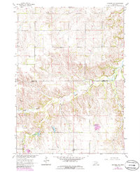
1963 Map of Orchard NW
USGS Topo · Published 1986About this map
Verdigre Creek and its complex network of tributaries, including the South Branch and East Branch, define this rural landscape along the boundary of Knox and Antelope Counties. Surveyed in the early 1960s with updates into the mid-1980s, the map illustrates a landscape shaped by water and small-scale land use. A localized Fish Hatchery near Hathaway Slough and Springs Creek points to the area's natural resource management, while the presence of Enterprise Cem and Pleasant View Cem provide critical anchors for those researching the genealogy of these plains townships. The terrain is marked by the branching paths of Cottonwood Creek and Hay Creek, showing the drainage patterns typical of the Nebraska prairie before more modern agricultural shifts fully reshaped the topography.
Find a feature on this map
12 named features on this map. Tap any name to fly to it.
Don’t see what you’re looking for? This feature index may not catch every label — zoom into the map to look around manually.
Map Details
Editions of this 1963 Orchard NW Map
2 editions found
Other maps of this area

1954 · Walnut
USGS Topo · 1:24,000

1954 · Verdigre
USGS Topo · 1:24,000

1954 · Star
USGS Topo · 1:24,000

1955 · O'Neill
USGS Topo · 1:250,000

1959 · O'Neill
USGS Topo · 1:250,000

1963 · Orchard NE
USGS Topo · 1:24,000

1963 · Venus
USGS Topo · 1:24,000

1963 · Royal
USGS Topo · 1:24,000

1963 · Orchard
USGS Topo · 1:24,000

1963 · Ewing
USGS Topo · 1:24,000