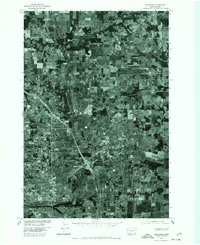
1975 Map of Orchards
USGS Topo · Published 1977About this map
Orchards and the surrounding Clark County landscape are captured here in mid-1970s detail, showing a region in the midst of suburban expansion. This orthophotoquad, produced by the U.S. Geological Survey in cooperation with the U. S. Corps of Engineers, utilizes aerial photography to reveal the transition from traditional agriculture to residential development. The grid of rural fields in the north near Brush Prairie contrasts sharply with the intensifying cloverleaf interchanges and housing blocks of Vancouver to the southwest. The course of Salmon Creek meanders through the upper portion of the map, providing a natural boundary to the rectilinear parceling of the land. For researchers, this imagery offers a precise record of late-century land use, from the established settlement at Sifton to the emerging highway corridors that would define the modern metropolitan area.
Find a feature on this map
5 named features on this map. Tap any name to fly to it.
Don’t see what you’re looking for? This feature index may not catch every label — zoom into the map to look around manually.
Map Details
Editions of this 1975 Orchards Map
This is the sole edition of this map. No revisions or reprints were ever made.
Other maps of this area

1897 · Portland
USGS Topo · 1:62,500

1905 · Portland
USGS Topo · 1:62,500

1918 · Troutdale
USGS Topo · 1:62,500

1934 · Troutdale
USGS Topo · 1:48,000

1940 · Portland
USGS Topo · 1:62,500

1940 · La Center
USGS Topo · 1:62,500

1941 · Yacolt
USGS Topo · 1:62,500

1941 · Camas
USGS Topo · 1:62,500

1942 · Camas
USGS Topo · 1:62,500

1948 · Vancouver
USGS Topo · 1:250,000