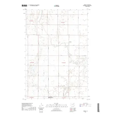
2017 Map of Ordway
USGS Topo · Published 2017About this map
Elm River meanders through this section of Brown County, north of Aberdeen, defining a landscape of agricultural sections and growing suburban developments. The small settlement of Ordway sits near the river's bend, while the northern edge of the city of Aberdeen begins to encroach from the south with residential street patterns like Prairiewood Dr and Ironwood Dr. The map illustrates the transition from the traditional grid of rural section roads, such as 125th St and 388th Ave, to the more irregular residential layouts near the municipal boundary. To the west, Alkali Lake provides a natural landmark within the predominantly level terrain. This 2017 survey serves as a modern record of the land use surrounding the Elm River valley, documenting the persistent rural character alongside late 20th-century urban expansion.
Find a feature on this map
32 named features on this map. Tap any name to fly to it.
Don’t see what you’re looking for? This feature index may not catch every label — zoom into the map to look around manually.
Map Details
Editions of this 2017 Ordway Map
This is the sole edition of this map. No revisions or reprints were ever made.
Other maps of this area

1894 · Columbia
USGS Topo · 1:62,500

1895 · Aberdeen
USGS Topo · 1:125,000

1896 · Columbia
USGS Topo · 1:125,000

1899 · Ellendale
USGS Topo · 1:125,000

1899 · Northville
USGS Topo · 1:125,000

1952 · Columbia
USGS Topo · 1:24,000

1952 · Ordway
USGS Topo · 1:24,000

1952 · Columbia NE
USGS Topo · 1:24,000

1952 · Westport
USGS Topo · 1:24,000

1952 · Richmond NE
USGS Topo · 1:24,000
Featured Places
- Aberdeen, SD
- Ordway, SD
- Prairie Wood Village Addition, SD
- Lincoln Township, SD
- Deevaan Villa Development, SD