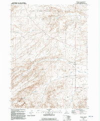
1992 Map of Oreana
USGS Topo · Published 1992About this map
Oreana serves as the primary settlement hub for this high-desert Owyhee County landscape, situated along the Boise Meridian where the terrain begins its ascent from the river flats toward the mountains. The map documents a land shaped by drainage systems like Pickett Creek, Hart Creek, and Catherine Creek, which flow toward the northern ranchlands. Evidence of early land use and local heritage is found at the Cem and Corral located just south of the main townsite. The northern portion of the map is dominated by the Snake River Birds of Prey Area, highlighting the conservation status of the canyonlands. Roadways such as Triangle Road and Castle Creek Road connect this remote ranching community to the broader region, while landmarks like Fossil Butte and Fossil Creek hint at the area's geological and paleontological significance.
Find a feature on this map
16 named features on this map. Tap any name to fly to it.
Don’t see what you’re looking for? This feature index may not catch every label — zoom into the map to look around manually.
Map Details
Editions of this 1992 Oreana Map
This is the sole edition of this map. No revisions or reprints were ever made.
Other maps of this area

1892 · Bisuka
USGS Topo · 1:125,000

1892 · Silver City
USGS Topo · 1:125,000

1894 · Bisuka
USGS Topo · 1:125,000

1894 · Silver City
USGS Topo · 1:125,000

1898 · Silver City
USGS Topo · 1:125,000

1947 · Wild Horse Butte
USGS Topo · 1:24,000

1948 · Castle Butte
USGS Topo · 1:24,000

1948 · Wild Horse Butte
USGS Topo · 1:24,000

1948 · Sinker Butte
USGS Topo · 1:24,000

1949 · Sinker Butte
USGS Topo · 1:24,000