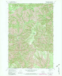
1967 Map of Oregon Butte
USGS Topo · Published 1983About this map
Umatilla National Forest occupies this high-elevation landscape in the Blue Mountains, where the deep drainage of the West Fork Wenaha River carves through the basaltic plateaus. The topography is dominated by long, parallel ridgelines such as Green Ridge, French Ridge, and Grizzly Bear Ridge, which served as the primary conduits for early forest travel. At the height of the range, the Oregon Butte Lookout stands near West Butte, providing a strategic vantage over a network of vital water sources. These dispersed springs, including Moolack, Hatfield, and Emergency Spring, were critical for supporting both sheep grazing and early fire suppression efforts. The presence of features like Pearson Spring and Rettkowski Spring suggests the historical importance of the high country for seasonal range management during the mid-20th century.
Find a feature on this map
41 named features on this map. Tap any name to fly to it.
Don’t see what you’re looking for? This feature index may not catch every label — zoom into the map to look around manually.
Map Details
Editions of this 1967 Oregon Butte Map
3 editions found
Other maps of this area

1937 · Pomeroy
USGS Topo · 1:96,000

1942 · Pomeroy
USGS Topo · 1:125,000

1955 · Pullman
USGS Topo · 1:250,000

1955 · Grangeville
USGS Topo · 1:250,000

1958 · Pullman
USGS Topo · 1:250,000

1959 · Grangeville
USGS Topo · 1:250,000

1967 · Eden
USGS Topo · 1:24,000

1967 · Elbow Creek
USGS Topo · 1:24,000

1967 · Oregon Butte
USGS Topo · 1:24,000

1967 · Stentz Spring
USGS Topo · 1:24,000