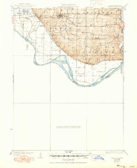
1926 Map of Oregon
USGS Topo · Published 1950About this map
The town of Oregon sits prominently atop the loess bluffs overlooking the Missouri River valley, serving as a focal point for this 1920s-era landscape. The region's agricultural and educational infrastructure is remarkably dense, evidenced by a network of rural schoolhouses including Mayflower School, Bluff City School, and Chambers School. The terrain is defined by the sharp contrast between the dissected uplands and the broad, flat floodplain to the west, where the Chicago Burlington and Quincy railroad tracks skirt the base of the hills. Water management in the lowlands is represented by the Squaw Creek Ditch, while the natural meandering of the Missouri River and the Nodaway River dictates the county boundaries. This survey, updated with highway revisions by C.L.Sadler, documents the transition from early river-and-rail reliance toward an increasingly road-connected rural society.
Find a feature on this map
32 named features on this map. Tap any name to fly to it.
Don’t see what you’re looking for? This feature index may not catch every label — zoom into the map to look around manually.
Map Details
Editions of this 1926 Oregon Map
3 editions found
Other maps of this area

1885 · Atchison
USGS Topo · 1:125,000

1888 · Atchison
USGS Topo · 1:125,000

1893 · Atchison
USGS Topo · 1:125,000

1920 · Craig
USGS Topo · 1:62,500

1924 · St. Joseph
USGS Topo · 1:62,500

1926 · Atchison
USGS Topo · 1:62,500

1926 · Saint Joseph
USGS Topo · 1:62,500

1926 · Oregon
USGS Topo · 1:62,500

1926 · Maitland
USGS Topo · 1:62,500

1927 · Dearborn
USGS Topo · 1:62,500