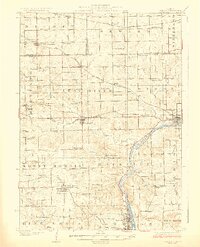
1924 Map of Oregon
USGS Topo · Published 1924About this map
The Rock River valley serves as the central artery for this portion of Northern Illinois, winding through the townships of Rockvale and Oregon. In the early 1920s, the landscape is defined by a dense grid of rural one-room schoolhouses, such as Hoisington School, White Eagle School, and Triumph School, reflecting a highly localized educational system. Three major rail lines, including the Chicago Milwaukee and St Paul and the Chicago Great Western, bisect the rolling terrain, facilitating the growth of agricultural hubs like Leaf River and Byron. The map documents a mature farm economy where small settlements like Adeline and Seward are closely integrated with their church parishes, including St Thomas Church and Ridott Church. This era marks the height of the traditional township system before later 20th-century consolidation, preserving the exact locations of family-named landmarks and long-established homesteads.
Find a feature on this map
84 named features on this map. Tap any name to fly to it.
Don’t see what you’re looking for? This feature index may not catch every label — zoom into the map to look around manually.
Map Details
Editions of this 1924 Oregon Map
3 editions found
Other maps of this area

1917 · Kings
USGS Topo · 1:62,500

1918 · Rockford
USGS Topo · 1:62,500

1918 · Dixon
USGS Topo · 1:62,500

1918 · Kings
USGS Topo · 1:62,500

1922 · Oregon
USGS Topo · 1:62,500

1924 · Oregon
USGS Topo · 1:62,500

1930 · Woodsung
USGS Topo · 1:48,000

1932 · Pecatonica
USGS Topo · 1:62,500

1936 · Pecatonica
USGS Topo · 1:62,500

1938 · Rockford
USGS Topo · 1:62,500