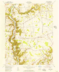
1955 Map of Oregonia
USGS Topo · Published 1956About this map
The ancient earthworks of Fort Ancient State Park anchor this mid-century survey of Warren County, showcasing the complex terrain where Shawnee Run and Randall Run meet the Little Miami River. This landscape reflects a deep history of human activity, from the prehistoric Burial Mounds and Stone Circle at the park to the 19th-century industrial footprint of Mathers Mills. The Pennsylvania Railroad tracks follow the river's winding course, serving small riverside communities like Oregonia while the higher ground is characterized by a network of rural routes such as Old C C C Road and Clarksville Road.
Find a feature on this map
75 named features on this map. Tap any name to fly to it.
Don’t see what you’re looking for? This feature index may not catch every label — zoom into the map to look around manually.
Map Details
Editions of this 1955 Oregonia Map
2 editions found
Other maps of this area

1907 · Blanchester
USGS Topo · 1:62,500

1913 · Waynesville
USGS Topo · 1:62,500

1914 · Morrow
USGS Topo · 1:62,500

1915 · Waynesville
USGS Topo · 1:62,500

1916 · Morrow
USGS Topo · 1:62,500

1917 · Xenia
USGS Topo · 1:62,500

1947 · Columbus
USGS Topo · 1:250,000

1953 · Cincinnati
USGS Topo · 1:250,000

1955 · New Burlington
USGS Topo · 1:24,000
1955 · Lebanon
USGS Topo · 1:24,000