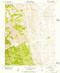
1955 Map of Orestimba Peak
USGS Topo · Published 1955About this map
Orestimba Peak serves as the high point in this remote stretch of the Diablo Range during the mid-1950s, overlooking a landscape defined by ranching and resource extraction. The terrain is marked by a network of windmills and reservoirs, suggesting a working landscape focused on livestock and water management. Watercourses like Crow Creek and Orestimba Creek carve through the hills, meeting at the Orestimba Narrows near the small settlement of Orestimba. In the lower elevations to the east, the transition into Bennett Valley is evidenced by more frequent infrastructure, including multiple quarries and established roadways. This survey captures a moment when the rugged interior of Stanislaus County relied heavily on independent water sources, with numerous unnamed springs and small reservoirs scattered among peaks like Black Mtn and Crow Hill.
Find a feature on this map
16 named features on this map. Tap any name to fly to it.
Don’t see what you’re looking for? This feature index may not catch every label — zoom into the map to look around manually.
Map Details
Editions of this 1955 Orestimba Peak Map
3 editions found
Other maps of this area

1916 · Crows Landing
USGS Topo · 1:31,680

1916 · Patterson
USGS Topo · 1:31,680

1917 · Newman
USGS Topo · 1:31,680

1919 · Orestimba
USGS Topo · 1:62,500

1919 · Orestimba Creek
USGS Topo · 1:31,680

1920 · Pacheco Pass
USGS Topo · 1:62,500

1921 · Gilroy Hot Springs
USGS Topo · 1:62,500

1922 · Howard Ranch
USGS Topo · 1:31,680

1938 · Mt. Boardman
USGS Topo · 1:62,500

1939 · Gilroy Hot Springs
USGS Topo · 1:62,500