
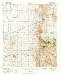
1941 Map of Organ Peak
USGS Topo · Published 1961About this map
The high peaks of Organ Peak and Organ Needle dominate this early 1940s landscape east of Las Cruces. The settlement at Organ serves as a focal point near San Augustin Pass, where U.S. 70 cuts through the steep terrain. This survey captures a specific era of land use in Dona Ana County, where cattle ranching and early tourism coexisted. Noteworthy family-named holdings like the Will F. Isaacs Ranch and Cox Home Ranch are situated alongside the Hayner Resort and the famed Dripping Springs. To the west, the Jornada Experimental Range and the campus of New Mexico State College mark the transition toward the agricultural valley, while smaller landmarks like the Douglas Sch and a remote Landing Field provide insights into the social and physical infrastructure of the pre-war period.
Find a feature on this map
68 named features on this map. Tap any name to fly to it.
Don’t see what you’re looking for? This feature index may not catch every label — zoom into the map to look around manually.
Map Details
Editions of this 1941 Organ Peak Map
2 editions found
Other maps of this area

1891 · Las Cruces
USGS Topo · 1:125,000

1893 · Las Cruces
USGS Topo · 1:125,000

1916 · Tonuco
USGS Topo · 1:125,000

1916 · Point Of Sands
USGS Topo · 1:125,000

1932 · Tonuco
USGS Topo · 1:125,000

1940 · Newman
USGS Topo · 1:62,500

1941 · Las Cruces
USGS Topo · 1:62,500

1943 · La Mesa
USGS Topo · 1:62,500

1943 · Parker Lake
USGS Topo · 1:62,500

1943 · Newman
USGS Topo · 1:62,500