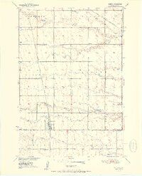
1951 Map of Orient
USGS Topo · Published 1951About this map
Orient stands as a central prairie settlement in this early 1950s survey, situated where the Chicago Milwaukee St Paul and Pacific railroad terminates. The landscape reflects a well-organized agricultural society defined by its local institutions and township grids. A string of rural schoolhouses, including Selting Sch, Ross Sch, and Gaffney Sch, are distributed across the terrain, illustrating the historical density of the rural school district system before consolidation. Just south of the town center, the Orient-Prairieview Cem serves as a significant landmark for genealogical research. The northern portion of the map is traversed by the Chicago and North Western railroad, while water features like Lake Nora and the winding Gooder Creek provide the primary drainage for the surrounding fields of Tamworth and Lafoon townships.
Find a feature on this map
18 named features on this map. Tap any name to fly to it.
Don’t see what you’re looking for? This feature index may not catch every label — zoom into the map to look around manually.
Map Details
Editions of this 1951 Orient Map
2 editions found
Other maps of this area

1899 · Northville
USGS Topo · 1:125,000

1899 · Redfield
USGS Topo · 1:125,000

1951 · Orient
USGS Topo · 1:24,000

1951 · Orient SW
USGS Topo · 1:24,000

1951 · Polo
USGS Topo · 1:24,000

1951 · Orient NW
USGS Topo · 1:24,000

1952 · Faulkton West
USGS Topo · 1:24,000

1952 · Faulkton East
USGS Topo · 1:24,000

1953 · Huron
USGS Topo · 1:250,000

1954 · Aberdeen
USGS Topo · 1:250,000