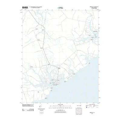
2010 Map of Oriental
USGS Topo · Published 2010About this map
Oriental serves as the focal point for this maritime landscape where the Neuse River meets a network of protected creeks and points. The town's reliance on the water is evident through the development of Oriental Harbor Marina and Clancys Marina, which anchor the local waterfront near Blackwell Point. Further north and east, the map details the smaller, dispersed settlements of Whortonsville and Pamlico, linked by roads that weave around the intricate fingers of Broad Creek and Orchard Creek. The interior reveals a pattern of rural crossroads and farming communities like Merritt, Moores Corner, and Gibbton. Genealogists and local historians can trace the relationship between family landholdings and the water at locations such as Graveyard Point and Wiggins Point, documenting the coastal topography of Pamlico County at the start of the twenty-first century.
Find a feature on this map
63 named features on this map. Tap any name to fly to it.
Don’t see what you’re looking for? This feature index may not catch every label — zoom into the map to look around manually.
Map Details
Editions of this 2010 Oriental Map
This is the sole edition of this map. No revisions or reprints were ever made.
Other maps of this area

1948 · Oriental
USGS Topo · 1:24,000

1949 · Merrimon
USGS Topo · 1:24,000

1949 · South River
USGS Topo · 1:24,000

1949 · Cherry Point
USGS Topo · 1:24,000

1950 · South River
USGS Topo · 1:24,000

1950 · Vandemere
USGS Topo · 1:24,000

1950 · Jones Bay
USGS Topo · 1:24,000

1950 · Arapahoe
USGS Topo · 1:24,000

1951 · Arapahoe
USGS Topo · 1:24,000
1951 · Merrimon
USGS Topo · 1:24,000