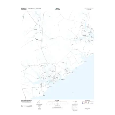
2013 Map of Oriental
USGS Topo · Published 2013About this map
Oriental and the surrounding coastal reaches of the Neuse River define this portion of Pamlico County. The maritime character of the region is evident in the concentration of boat-oriented infrastructure, including the Oriental Harbor Marina and Claneys Marina near Chadwick Point. Small settlements and landing points dot the intricate network of creeks and bays, with Whortonsville situated near the mouth of Broad Cr and Gibbton tucked further inland along the upper reaches of Trent Cr. The landscape is a complex puzzle of points and guts, where land and water meet at features like Windmill Point and Whittaker Point. Moving inland, the terrain transitions to agricultural and residential use near communities such as Merritt and Kershaw. The presence of the Benton Farm Airport near Pamlico underscores the local significance of private aviation in this water-bound landscape.
Find a feature on this map
149 named features on this map. Tap any name to fly to it.
Don’t see what you’re looking for? This feature index may not catch every label — zoom into the map to look around manually.
Map Details
Editions of this 2013 Oriental Map
This is the sole edition of this map. No revisions or reprints were ever made.
Other maps of this area

1948 · Oriental
USGS Topo · 1:24,000

1949 · Merrimon
USGS Topo · 1:24,000

1949 · South River
USGS Topo · 1:24,000

1949 · Cherry Point
USGS Topo · 1:24,000

1950 · South River
USGS Topo · 1:24,000

1950 · Vandemere
USGS Topo · 1:24,000

1950 · Jones Bay
USGS Topo · 1:24,000

1950 · Arapahoe
USGS Topo · 1:24,000

1951 · Arapahoe
USGS Topo · 1:24,000
1951 · Merrimon
USGS Topo · 1:24,000