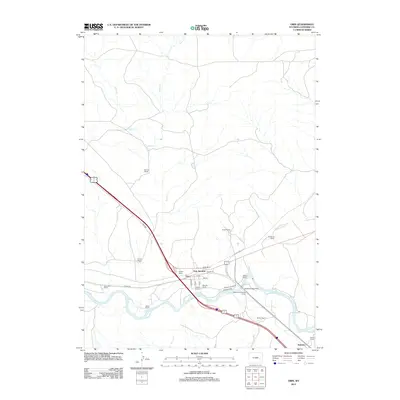
2012 Map of Orin
USGS Topo · Published 2012About this map
The N Platte River corridor near Orin Junction serves as the focal point for this Converse County landscape, where modern transportation routes intersect with deep-rooted western ranching history. The mapping of numerous family-named properties, including the Townsend Ranch, Schneider Ranch, and the Nylen and Gillespie Ranch, reveals the enduring agricultural footprint along the river bottom and the surrounding drainages of Sand Cr and Smith Cr. Near the confluence of these waterways, the James Bridger Ferry and Bridger Xing mark a crossing point of immense historical significance, anchoring the small settlement of Orin and the junction of major transit ways like Orin Way. This 2012 survey provides a detailed view of the localized road network, including Irvine Rd and the street grids at the core of the junction, as the terrain transitions toward the southeastern corner near Ammon.
Find a feature on this map
33 named features on this map. Tap any name to fly to it.
Don’t see what you’re looking for? This feature index may not catch every label — zoom into the map to look around manually.
Map Details
Editions of this 2012 Orin Map
This is the sole edition of this map. No revisions or reprints were ever made.
Other maps of this area

1949 · Shawnee
USGS Topo · 1:24,000

1949 · Irvine
USGS Topo · 1:24,000

1949 · Cedar Hill
USGS Topo · 1:24,000

1949 · Dilts Ranch
USGS Topo · 1:24,000

1949 · Orin
USGS Topo · 1:24,000

1949 · Antelope Creek
USGS Topo · 1:24,000

1950 · Glendo
USGS Topo · 1:24,000

1950 · Orin
USGS Topo · 1:24,000
1950 · Irvine
USGS Topo · 1:24,000
1950 · Antelope Creek
USGS Topo · 1:24,000