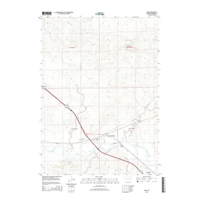
2015 Map of Orin
USGS Topo · Published 2015About this map
The North Platte River carves a significant path through this Converse County landscape, serving as a historic corridor for transportation and settlement. Near the river's bend, Orin Junction and the small community of Orin stand at a vital crossroads where Orin Way and the Yellowstone Hwy intersect. This area is deeply tied to the pioneering history of the West, evidenced by the location of the James Bridger Ferry and the nearby Bridger Xing, which provided essential river passage for early travelers.
Find a feature on this map
20 named features on this map. Tap any name to fly to it.
Don’t see what you’re looking for? This feature index may not catch every label — zoom into the map to look around manually.
Map Details
Editions of this 2015 Orin Map
This is the sole edition of this map. No revisions or reprints were ever made.
Other maps of this area

1949 · Shawnee
USGS Topo · 1:24,000

1949 · Irvine
USGS Topo · 1:24,000

1949 · Cedar Hill
USGS Topo · 1:24,000

1949 · Dilts Ranch
USGS Topo · 1:24,000

1949 · Orin
USGS Topo · 1:24,000

1949 · Antelope Creek
USGS Topo · 1:24,000

1950 · Glendo
USGS Topo · 1:24,000

1950 · Orin
USGS Topo · 1:24,000
1950 · Irvine
USGS Topo · 1:24,000
1950 · Antelope Creek
USGS Topo · 1:24,000