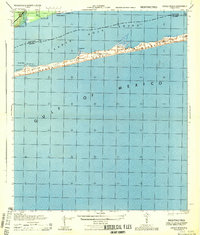
1944 Map of Oriole Beach
USGS Topo · Published 1944About this map
Santa Rosa Island stretches across the center of this coastal survey, dividing the turquoise waters of the Gulf of Mexico from the sheltered reaches of Santa Rosa Sound. Much of the barrier island is designated as the Santa Rosa National Monument, a protected landscape before the mid-century surge in coastal development. Along the northern shoreline, the settlement of Oriole Beach is nestled near the intersection of the county boundary between Santa Rosa and Escambia counties.
Find a feature on this map
19 named features on this map. Tap any name to fly to it.
Don’t see what you’re looking for? This feature index may not catch every label — zoom into the map to look around manually.
Map Details
Editions of this 1944 Oriole Beach Map
This is the sole edition of this map. No revisions or reprints were ever made.
Other maps of this area

1921 · Holley
USGS Topo · 1:62,500

1921 · Pensacola
USGS Topo · 1:62,500

1936 · Holley
USGS Topo · 1:48,000

1938 · Holley
USGS Topo · 1:62,500

1941 · Pensacola
USGS Topo · 1:62,500

1942 · Pensacola
USGS Topo · 1:62,500

1944 · Gulf Breeze
USGS Topo · 1:25,000
1944 · Garcon Point
USGS Topo · 1:25,000
1944 · Pensacola
USGS Topo · 1:25,000

1957 · Pensacola
USGS Topo · 1:250,000