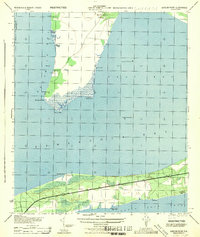
1944 Map of Garcon Point
USGS Topo · Published 1944About this map
The coastal peninsula of Garcon Point and the adjacent shoreline of Santa Rosa Sound dominate this mid-century War Department survey. This strategic coastal environment features a mix of tidal bayous, such as Red Bayou, Basin Bayou, and Alligator Bayou, carved into the western marshes of the peninsula. Along the southern coast, the development of Woodlawn Beach and Tiger Point is visible along the path of Route 98, providing a look at the area's transition into a more settled residential and recreational landscape. The map also highlights several triangulation stations and benchmarks from 1934, including White 1934 and Pear 1934, alongside the northern Black Hammock Cem. Significant military presence is noted at the U S Naval Res on the sound, reflecting the area's importance for harbor defense during the Second World War.
Find a feature on this map
30 named features on this map. Tap any name to fly to it.
Don’t see what you’re looking for? This feature index may not catch every label — zoom into the map to look around manually.
Map Details
Editions of this 1944 Garcon Point Map
This is the sole edition of this map. No revisions or reprints were ever made.
Other maps of this area

1920 · Milton
USGS Topo · 1:62,500

1921 · Holley
USGS Topo · 1:62,500

1921 · Pensacola
USGS Topo · 1:62,500

1934 · Harold
USGS Topo · 1:62,500

1936 · Holley
USGS Topo · 1:48,000

1937 · Harold
USGS Topo · 1:62,500

1938 · Holley
USGS Topo · 1:62,500

1938 · Harold
USGS Topo · 1:62,500

1941 · Pensacola
USGS Topo · 1:62,500

1941 · Milton
USGS Topo · 1:62,500