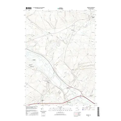
2016 Map of Oriskany
USGS Topo · Published 2016About this map
The Mohawk River and the legendary Erie Canal define the industrial and transit corridor between Rome and Whitesboro in this 2016 survey. The landscape is deeply tied to early American history, notably marked by the Oriskany Battle Monument and the Unknown Soldier Monument situated near the village of Oriskany. These landmarks commemorate the pivotal 1777 Revolutionary War battle, set within a terrain where Oriskany Creek and Ninemile Creek converge toward the Mohawk Valley floor.
Find a feature on this map
107 named features on this map. Tap any name to fly to it.
Don’t see what you’re looking for? This feature index may not catch every label — zoom into the map to look around manually.
Map Details
Editions of this 2016 Oriskany Map
This is the sole edition of this map. No revisions or reprints were ever made.
Other maps of this area

1895 · Oriskany
USGS Topo · 1:62,500

1897 · Remsen
USGS Topo · 1:62,500

1898 · Utica
USGS Topo · 1:62,500

1898 · Oriskany
USGS Topo · 1:62,500

1900 · Utica
USGS Topo · 1:62,500

1900 · Remsen
USGS Topo · 1:62,500

1904 · Boonville
USGS Topo · 1:62,500

1943 · Utica East
USGS Topo · 1:24,000
1945 · Utica East
USGS Topo · 1:31,680
1945 · South Trenton
USGS Topo · 1:31,680