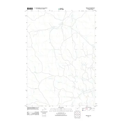
2012 Map of Oriva NW
USGS Topo · Published 2012About this map
Jamison Prong Wildcat Cr and its various tributaries define this section of the Powder River Basin in Campbell County, as shown in this 2012 topographic record. The landscape is characterized by an intricate network of drainage systems, including Road Prong, Nine T Bar Cr, and Twentymile Cr, which indicate a highly dissected prairie environment. Human presence in this expansive ranching country is marked by scattered stock ponds and water management features like Gupton Reservoir. Roads are sparse across the terrain, with Fitch Rd serving as a primary corridor through the southern portion of the area. This map provides a detailed view of the natural watercourses, such as Lone Tree Prong and Rawhide Cr, before they join larger systems, offering a clear picture of the hydraulic patterns in this part of Wyoming.
Find a feature on this map
9 named features on this map. Tap any name to fly to it.
Don’t see what you’re looking for? This feature index may not catch every label — zoom into the map to look around manually.
Map Details
Editions of this 2012 Oriva NW Map
This is the sole edition of this map. No revisions or reprints were ever made.
Other maps of this area

1954 · Gillette
USGS Topo · 1:250,000

1955 · Gillette
USGS Topo · 1:250,000

1958 · Gillette
USGS Topo · 1:250,000

1962 · Gillette
USGS Topo · 1:250,000
1971 · Wildcat
USGS Topo · 1:24,000
1971 · Oriva NW
USGS Topo · 1:24,000
1971 · Oriva
USGS Topo · 1:24,000
1971 · Calf Creek
USGS Topo · 1:24,000
1971 · Gillette West
USGS Topo · 1:24,000
1971 · Rawhide School
USGS Topo · 1:24,000