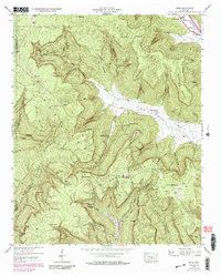
1947 Map of Orme
USGS Topo · Published 1986About this map
Cumberland Mountain dominates this landscape, where deep hollows and narrow coves define the rural settlement patterns of Marion County. The town of Orme sits tucked into a valley near Turnpike Point, while smaller communities like Lodge and The Crossroads are scattered among the ridges. Local social centers include Louis Chapel, Sweden Cove School, and Orme Mountain School, reflecting a time when education and worship were centered in these isolated mountain pockets.
Find a feature on this map
59 named features on this map. Tap any name to fly to it.
Don’t see what you’re looking for? This feature index may not catch every label — zoom into the map to look around manually.
Map Details
Editions of this 1947 Orme Map
4 editions found
Other maps of this area

1886 · Stevenson
USGS Topo · 1:125,000

1892 · Stevenson
USGS Topo · 1:125,000

1895 · Stevenson
USGS Topo · 1:125,000

1895 · Sewanee
USGS Topo · 1:125,000

1936 · Sewanee
USGS Topo · 1:24,000

1936 · Orme
USGS Topo · 1:24,000

1936 · Bridgeport
USGS Topo · 1:24,000

1936 · Sinking Cove
USGS Topo · 1:24,000

1936 · Monteagle
USGS Topo · 1:24,000

1936 · White City
USGS Topo · 1:24,000