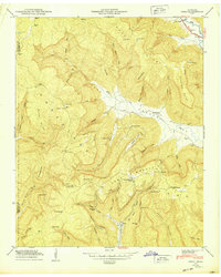
1950 Map of Orme
USGS Topo · Published 1950About this map
The town of Orme and the high ridges of Cumberland Mountain define this 1950 topographical study, capturing a landscape deeply shaped by its geology and early 20th-century travel routes. The Dixie Highway cuts through the northeast corner along Battle Creek, providing a stark contrast to the winding tracks that lead into isolated valleys like Sweden Cove and Beene Cove. The settlement pattern follows these natural coves, where local life centered around institutions such as the Sweden Cove School and Lous Chapel.
Find a feature on this map
66 named features on this map. Tap any name to fly to it.
Don’t see what you’re looking for? This feature index may not catch every label — zoom into the map to look around manually.
Map Details
Editions of this 1950 Orme Map
This is the sole edition of this map. No revisions or reprints were ever made.
Other maps of this area

1886 · Stevenson
USGS Topo · 1:125,000

1892 · Stevenson
USGS Topo · 1:125,000

1895 · Stevenson
USGS Topo · 1:125,000

1895 · Sewanee
USGS Topo · 1:125,000

1936 · Sewanee
USGS Topo · 1:24,000

1936 · Orme
USGS Topo · 1:24,000

1936 · Bridgeport
USGS Topo · 1:24,000

1936 · Sinking Cove
USGS Topo · 1:24,000

1936 · Monteagle
USGS Topo · 1:24,000

1936 · White City
USGS Topo · 1:24,000