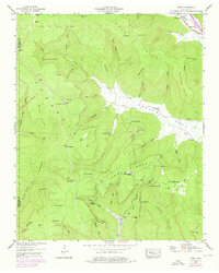
1947 Map of Orme
USGS Topo · Published 1976About this map
Cumberland Mountain dominates this landscape, where the deeply carved coves of the Tennessee valley meet the plateau. In the late 1940s, the settlement of Orme sat at the base of the mountain near the Orme City Boundary, serving as a hub for local families near the Orme Mountain School. The geography is defined by numerous family-named coves and points, such as Sweden Cove, Nancy Winn Cove, and Ballard Point, reflecting a long history of upland settlement.
Find a feature on this map
64 named features on this map. Tap any name to fly to it.
Don’t see what you’re looking for? This feature index may not catch every label — zoom into the map to look around manually.
Map Details
Editions of this 1947 Orme Map
4 editions found
Other maps of this area

1886 · Stevenson
USGS Topo · 1:125,000

1892 · Stevenson
USGS Topo · 1:125,000

1895 · Stevenson
USGS Topo · 1:125,000

1895 · Sewanee
USGS Topo · 1:125,000

1936 · Sewanee
USGS Topo · 1:24,000

1936 · Orme
USGS Topo · 1:24,000

1936 · Bridgeport
USGS Topo · 1:24,000

1936 · Sinking Cove
USGS Topo · 1:24,000

1936 · Monteagle
USGS Topo · 1:24,000

1936 · White City
USGS Topo · 1:24,000