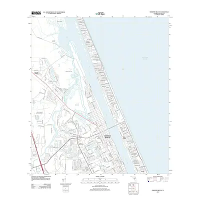
2012 Map of Ormond Beach
USGS Topo · Published 2012About this map
The coastal geography of Ormond Beach is defined by the parallel courses of the Tomoka River and Halifax River as they flow toward the Tomoka Basin and the Atlantic Ocean. This 2012 survey illustrates a landscape where early Florida heritage sites like the Addison Blockhouse and Anacape Mission sit in proximity to modern infrastructure, including the Ormond Beach Municipal Airport and Seabreeze High School. The map detail is particularly useful for genealogists, identifying numerous burial grounds such as Pilgrims Rest Cem, Oak Ridge Cem, and Hillside Cem. Residential patterns are clearly marked through established neighborhoods like Ellinor Village, National Gardens, and Ortona, while the northern reaches show the preservation of Bryan Island and the marshlands surrounding the river forks.
Find a feature on this map
214 named features on this map. Tap any name to fly to it.
Don’t see what you’re looking for? This feature index may not catch every label — zoom into the map to look around manually.
Map Details
Editions of this 2012 Ormond Beach Map
This is the sole edition of this map. No revisions or reprints were ever made.
Other maps of this area

1937 · Port Orange
USGS Topo · 1:48,000

1937 · Ormond
USGS Topo · 1:48,000

1943 · Port Orange
USGS Topo · 1:62,500

1944 · Ormond
USGS Topo · 1:62,500

1944 · Port Orange
USGS Topo · 1:62,500

1952 · Daytona Beach
USGS Topo · 1:24,000

1954 · Daytona Beach
USGS Topo · 1:250,000

1956 · Port Orange
USGS Topo · 1:24,000

1956 · Favoretta
USGS Topo · 1:24,000

1956 · Flagler Beach East
USGS Topo · 1:24,000
Featured Places
- Daytona Beach, FL
- Ormond Beach, FL
- Ellinor Village, Ormond Beach
- Ormond-by-the-Sea, FL
- Ortona, Daytona Beach