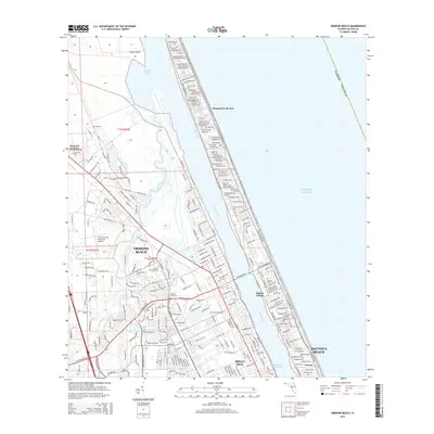
2015 Map of Ormond Beach
USGS Topo · Published 2015About this map
The Halifax River and the Intracoastal Waterway define the coastal geography of this Volusia County corridor, separating the mainland from the barrier island communities of Ormond-by-the-Sea and Ellinor Village. This mid-2010s survey reveals a landscape where residential expansion is balanced against significant protected or undeveloped areas like Bryan Island and the Tomoka Basin. Local genealogy and land use patterns are well-documented through several marked burial grounds, including Volusia Memorial Park, Hillside Cem, and Pilgrims Rest Cem. The infrastructure reflects a mix of tourism and local industry, centered around the Ormond Beach Municipal Airport and the educational hub at Daytona Coll. The street grid transitions from the dense coastal corridors along Ocean Shore Blvd and S Atlantic Ave to the spreading neighborhoods of Ormond Beach and Holly Hill.
Find a feature on this map
33 named features on this map. Tap any name to fly to it.
Don’t see what you’re looking for? This feature index may not catch every label — zoom into the map to look around manually.
Map Details
Editions of this 2015 Ormond Beach Map
This is the sole edition of this map. No revisions or reprints were ever made.
Other maps of this area

1937 · Port Orange
USGS Topo · 1:48,000

1937 · Ormond
USGS Topo · 1:48,000

1943 · Port Orange
USGS Topo · 1:62,500

1944 · Ormond
USGS Topo · 1:62,500

1944 · Port Orange
USGS Topo · 1:62,500

1952 · Daytona Beach
USGS Topo · 1:24,000

1954 · Daytona Beach
USGS Topo · 1:250,000

1956 · Port Orange
USGS Topo · 1:24,000

1956 · Favoretta
USGS Topo · 1:24,000

1956 · Flagler Beach East
USGS Topo · 1:24,000
Featured Places
- Daytona Beach, FL
- Ormond Beach, FL
- Ellinor Village, Ormond Beach
- Ormond-by-the-Sea, FL
- Ortona, Daytona Beach