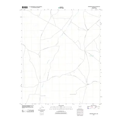
2010 Map of Orndorff Ranch
USGS Topo · Published 2010About this map
White Sands Missile Range dominates this portion of Socorro County, illustrating the significant federal footprint in the New Mexico desert during the early 21st century. The landscape is defined by the winding course of the Chupadera Arroyo, a seasonal drainage that carves through the arid terrain. Scattered ranching outposts like Orndorff Ranch and Fernandez Ranch reflect the area's agricultural roots, persisting alongside the modern military infrastructure. A network of specialized roads, including WSMR P Route 7 and WSMR S Route 3509, serves the missile range's operations, while remote water features such as Little Jug Tank provide essential resources in this dry environment. The map captures the quiet tension between traditional high-desert ranching and the strategic demands of contemporary defense aerospace testing.
Find a feature on this map
12 named features on this map. Tap any name to fly to it.
Don’t see what you’re looking for? This feature index may not catch every label — zoom into the map to look around manually.
Map Details
Editions of this 2010 Orndorff Ranch Map
This is the sole edition of this map. No revisions or reprints were ever made.
Other maps of this area

1916 · La Joya
USGS Topo · 1:125,000

1918 · Oscura Peak
USGS Topo · 1:125,000

1948 · Carthage
USGS Topo · 1:62,500

1948 · Bingham
USGS Topo · 1:62,500

1954 · Tularosa
USGS Topo · 1:250,000

1954 · Socorro
USGS Topo · 1:250,000

1958 · Socorro
USGS Topo · 1:250,000

1958 · Tularosa
USGS Topo · 1:250,000

1962 · Socorro
USGS Topo · 1:250,000
1972 · Sierra Larga North
USGS Topo · 1:24,000