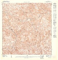
1947 Map of Orocovis SE
USGS Topo · Published 1947About this map
Cordillera Central defines the spine of this Puerto Rican interior, where the high mountain ridges serve as natural barriers and jurisdictional markers between the municipalities of Orocovis, Coamo, and Villalba. Topography recorded in 1943 reveals a complex landscape of steep ravines and prominent peaks like Cerro El Malo, where small mountain trails and homesites are perched high above the watershed. The drainage patterns are particularly intricate, with the Rio Bauta flowing northward while southern systems like Rio Toa Vaca and Rio Coamo carve deep paths through the Cuchilla de Coamo. This preliminary study shows the rural character of the central highlands before major modern infrastructure, focusing on the natural contours and the scattered homesteads that followed the ridges and creek beds of Quebrada Hayales and Rio Descalabrado.
Find a feature on this map
13 named features on this map. Tap any name to fly to it.
Don’t see what you’re looking for? This feature index may not catch every label — zoom into the map to look around manually.
Map Details
Editions of this 1947 Orocovis SE Map
This is the sole edition of this map. No revisions or reprints were ever made.
Other maps of this area

1945 · Rio Descalabrado
USGS Topo · 1:30,000

1946 · Coamo
USGS Topo · 1:30,000

1946 · Barranquitas
USGS Topo · 1:30,000

1946 · Orocovis
USGS Topo · 1:30,000
1947 · Orocovis NE
USGS Topo · 1:10,000
1947 · Orocovis SO
USGS Topo · 1:10,000
1947 · Orocovis NO
USGS Topo · 1:10,000
1947 · Rio Descalabrado NE
USGS Topo · 1:10,000
1947 · Coamo NO
USGS Topo · 1:10,000
1947 · Rio Descalabrado NO
USGS Topo · 1:10,000