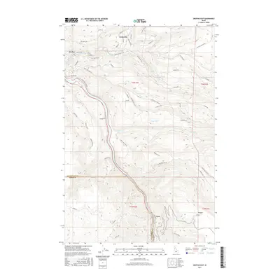
2017 Map of Orofino East
USGS Topo · Published 2017About this map
The Clearwater River carves a deep valley through this Idaho landscape, where the settlements of Orofino, Konkolville, and Greer sit along the river's eastern banks. This 2017 survey illustrates a rugged interface between the river valley and the elevated plateaus of Crockett Bench and the surrounding timbered ridges. A complex network of logging and access roads, such as Grangemont Rd and Dent Bridge Rd, connects the valley floor to high-elevation points like Harmony Hts. Local genealogy interests are centered on the Hill Cem near Orofino, as well as the outlying community of Fraser on the eastern edge of the quadrangle. Significant water systems, including Jim Ford Cr and Orofino Cr, cut through the terrain, defining the drainage patterns that have long influenced the region's development and transport routes.
Find a feature on this map
58 named features on this map. Tap any name to fly to it.
Don’t see what you’re looking for? This feature index may not catch every label — zoom into the map to look around manually.
Map Details
Editions of this 2017 Orofino East Map
This is the sole edition of this map. No revisions or reprints were ever made.
Other maps of this area

1924 · Kamiah
USGS Topo · 1:125,000

1955 · Pullman
USGS Topo · 1:250,000

1958 · Pullman
USGS Topo · 1:250,000

1961 · Ahsahka
USGS Topo · 1:62,500

1967 · Mohler
USGS Topo · 1:24,000

1967 · Sixmile Creek
USGS Topo · 1:24,000

1967 · Rudo
USGS Topo · 1:24,000

1967 · Orofino West
USGS Topo · 1:24,000
1967 · Woodland
USGS Topo · 1:24,000

1967 · Orofino East
USGS Topo · 1:24,000