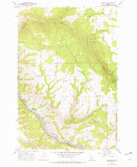
1967 Map of Woodland
USGS Topo · Published 1971About this map
Camas Prairie dominates the southwestern portion of this Idaho landscape, where the plateau drops sharply toward the Clearwater River. This 1967 field-checked survey reveals a rural network of small agricultural settlements and timber-adjacent communities, notably the town of Woodland and the smaller clusters of Harrisburg and Pardee Corner. The geography is defined by its dramatic relief, where the Woodland Grade and various jeep trails descend from the high prairie into the steep canyons carved by Lolo Creek and its tributaries. Along the river, the label for Tramway hints at historical mechanical transport used to move goods between the canyon floor and the heights of the prairie above. The map also delineates the eastern edge of the Nez Perce Indian Reservation Boundary, marking a clear administrative divide between tribal lands and the Clearwater National Forest.
Find a feature on this map
20 named features on this map. Tap any name to fly to it.
Don’t see what you’re looking for? This feature index may not catch every label — zoom into the map to look around manually.
Map Details
Editions of this 1967 Woodland Map
3 editions found
Other maps of this area

1924 · Kamiah
USGS Topo · 1:125,000

1924 · Weippe
USGS Topo · 1:125,000

1955 · Pullman
USGS Topo · 1:250,000

1956 · Hamilton
USGS Topo · 1:250,000

1958 · Pullman
USGS Topo · 1:250,000

1959 · Hamilton
USGS Topo · 1:250,000

1960 · Hamilton
USGS Topo · 1:250,000

1964 · Hamilton
USGS Topo · 1:250,000

1966 · Kooskia
USGS Topo · 1:24,000
1966 · Weippe South
USGS Topo · 1:24,000